Skeptophilia (skep-to-fil-i-a) (n.) - the love of logical thought, skepticism, and thinking critically. Being an exploration of the applications of skeptical thinking to the world at large, with periodic excursions into linguistics, music, politics, cryptozoology, and why people keep seeing the face of Jesus on grilled cheese sandwiches.
Showing posts with label meteorology. Show all posts

Monday, August 4, 2025

Thunderbolts and lightning (very very frightening)

The cause of lightning has been strangely elusive.

Oh, in the broadest-brush terms, we've understood it for a while.  The rapidly-rising column of air in a cumulonimbus cloud induces charge separation, resulting in an electric potential difference between the ground and the air.  At a potential of about three megavolts per meter, the dielectric strength of damp air is exceeded -- the maximum voltage it can withstand without the molecules ionizing, and becoming conductive to electrical current.  This creates a moving channel of ionized air called a stepped leader.  When the leader reaches the ground, the overall resistance between the ground and the cloud drops dramatically, and discharge occurs, called the return stroke.  This releases between two hundred megajoules and seven gigajoules of energy in a fraction of a second, heating the air column to around thirty thousand degrees Celsius -- five times hotter than the surface of the Sun.

That's the origin of both the flash of light and the shock wave in the air that we hear as thunder.

The problem is, there was no consensus on what exactly caused the very first step -- the charge separation in the cloud that triggers the voltage difference.  Some scientists believed that it was friction between the air and the updrafting raindrops (and hail) characteristic of a thundercloud, similar to the way you can induce a static charge on a balloon by rubbing it against your shirt.  But experiments weren't able to confirm that, and most places you look, you'll see words like "still being investigated" and "uncertain at best" and "poorly understood process."

Until now.

A team of scientists led by Victor Pasko of Pennsylvania State University have shown that the initiation of lightning is caused by a literal perfect storm of conditions.  They found that free "seed" electrons, knocked loose by cosmic rays, are accelerating into the rapidly-rising air column at "relativistic" speeds -- i.e., a significant fraction of the speed of light -- and then ram into nitrogen and oxygen atoms.  These collisions trigger a shower of additional electrons, causing an avalanche, which is then swept upward into the upper parts of the cloud.

This is what causes the charge separation, the voltage difference between top and bottom, and the eventual discharge we see as lightning.

It also produces electromagnetic radiation across the spectrum from radio waves to gamma rays, something that had been observed but never explained.

"By simulating conditions with our model that replicated the conditions observed in the field, we offered a complete explanation for the X-rays and radio emissions that are present within thunderclouds," Pasko said.  "We demonstrated how electrons, accelerated by strong electric fields in thunderclouds, produce X-rays as they collide with air molecules like nitrogen and oxygen, and create an avalanche of electrons that produce high-energy photons that initiate lightning...  [T]he high-energy X-rays produced by relativistic electron avalanches generate new seed electrons driven by the photoelectric effect in air, rapidly amplifying these avalanches.  In addition to being produced in very compact volumes, this runaway chain reaction can occur with highly variable strength, often leading to detectable levels of X-rays, while accompanied by very weak optical and radio emissions.  This explains why these gamma-ray flashes can emerge from source regions that appear optically dim and radio silent."

There's still a lot left to explain, however.  Also this week, a paper came out of Arizona State University about the astonishing "megaflash" that occurred in October 2017, where a single lightning bolt traveled over eight hundred kilometers -- from eastern Texas all the way to Kansas City.  Even though the megaflash dropped some cloud-to-ground leaders along the way, it didn't discharge completely until the very end.  Megaflashes are rare, but what conditions could lead to a main stepped leader (and the corresponding return stroke) extending that far before grounding are unknown.

So like with all good science, the new research answers some questions and raises others.  Here in upstate New York we're in thunderstorm season, and while we don't get the crazy storms they see in the southeast and midwest, we've had some powerful ones this summer.  I've always liked a good storm, as long as the lightning stays away from my house.  A friend of ours had his house struck by lightning a few years ago and it fried his electrical system (including his computer) -- something that leads me to unplug my laptop and router as soon as I hear rumbling.

Even if the mechanisms of lightning are now less mysterious, it's still just as dangerous.  Very very frightening, as Freddie Mercury observed.

****************************************


Tuesday, July 22, 2025

Weathering the storm

Something that really grinds my gears is how quick people can be to trumpet their own ignorance, seemingly with pride.

I recall being in a school board budget meeting some years ago, and the science department line items were being discussed.  One of the proposed equipment purchases that came up was an electronic weather station for the Earth Science classroom.  And a local attending the meeting said, loud enough for all to hear, "Why the hell do they need a weather station?  If I want to know what the weather is, I stick my head out the window!  Hurr hurr hurr hurr durr!"

Several of his friends joined in the laughter, while I -- and the rest of the science faculty in attendance -- sat there quietly attempting to bring our blood pressures back down to non-lethal levels.

What astonishes me about this idiotic comment is two things: (1) my aforementioned bafflement about why he was so quick to demonstrate to everyone at the meeting that he was ignorant; and (2) what it said about his own level of curiosity.  When I don't know something, my first thought is not to ridicule but to ask questions.  If I thought an electronic weather station might be an odd or a frivolous purchase, I would have asked what exactly the thing did, and how it was better than "sticking my head out the window."  The Earth Science teacher -- who was in attendance that evening -- could then have explained it to me.

And afterward, miracle of miracles, I might have learned something.

All sciences are to some extent prone to this "I'm ignorant and I'm proud of it" attitude by laypeople, but meteorology may be the worst.  How many times have you heard people say things like, "A fifty percent chance of rain?  How many jobs can you think of where you could get as good results by flipping a coin, and still get paid?"  It took me a fifteen-second Google search to find the weather.gov page explaining that the "probability of precipitation" percentages mean something a great deal more specific than the forecasters throwing their hands in the air and saying, "Might happen, might not."  A fifty-percent chance of rain means that in the forecast area, any given point has a fifty percent chance of receiving at least 0.01" of rain; from this it's obvious that if there's a fifty percent chance over a large geographical area, the likelihood of someone receiving rain in the region is much greater than fifty percent.  (These middling percentages are far more common in the northern hemisphere's summer, when much of the rain falls in the form of sporadic local thunderstorms that are extremely hard to predict precisely.  If you live in the US Midwest or anywhere in the eastern half of North America, you can probably remember times when you got rain and your friends five miles away didn't, or vice versa.)

[Image licensed under the Creative Commons Walter Baxter, The Milestone weather forecasting stone - geograph.org.uk - 1708774, CC BY-SA 2.0]

The problem is, meteorology is complex.  Computer models of the atmosphere rely on estimates of conditions (barometric pressure, temperature, humidity, air speed both vertically and horizontally, and particulate content, to name a few) along with mathematical equations describing how those quantities vary over time and influence each other.  The results are never completely accurate, and extending forward in time -- long-range forecasting -- is still nearly impossible except in the broadest-brush sense.  Add to that the fact there are weather phenomena that are still largely unexplained; one of the weirdest is the Catatumbo lightning, which occurs near where the Catatumbo River flows into Lake Maracaibo in Venezuela.  That one small region gets significant lightning 140 to 160 days a year, nine hours per day, and with lightning flashes from sixteen to forty times per minute.  The area sees the highest density of lightning in the world, at 250 strikes per square kilometer -- and no one knows why.

[Image licensed under the Creative Commons Fernando Flores, Catatumbo Lightning (141677107), CC BY-SA 3.0]

Despite the inaccuracies and the gaps in our understanding, we are far ahead of the idiotic "they're just flipping a coin" that the non-science types would have you believe.  The deadliest North American hurricane on record, the 1900 Galveston storm that took an estimated eight thousand lives, was as devastating as it was precisely because back then, forecasting was so rudimentary that almost no one knew it was coming.  Today we usually have days, sometimes weeks, of warning before major weather events -- and yet, if the prediction is off by a few hours or landfall is inaccurate by ten miles, people still complain that "the meteorologists are just making guesses."

What's grimly ironic is that we might get our chance to find out what it's like to go back to a United States where we actually don't have accurate weather forecasting, because Trump and his cronies have cut the National Weather Service and the National Oceanic and Atmospheric Administration to the bone.  The motivation was, I suspect, largely because of the Right's pro-fossil-fuels, anti-climate-change bias, but the result will be to hobble our ability to make precise forecasts and get people out of harm's way.  You think the central Texas floods in the first week of July were bad?

Keep in mind that Atlantic hurricane season has just started, as well as the western wildfire season.  The already understaffed NWS and NOAA offices are now running on skeleton crews, just at the point when skilled forecasters are needed the most.  My intuition is you ain't seen nothin' yet.

Oh, and don't ask FEMA to help you after the disaster hits.  That's been cut, too.  Following the Texas floods, thousands of calls from survivors to FEMA were never returned, because Homeland Security Secretary Kristi Noem was too busy cosplaying at Alligator Auschwitz to bother doing anything about the situation.  (She responded to criticism by stating that FEMA "responded to every caller swiftly and efficiently," following the Trump approach that all you have to do is lie egregiously and it automatically becomes true.)

Ignorance is nothing to be embarrassed about, but it's also nothing to be proud of.  And when people's ignorance impels them to elect ignorant ideologues as leaders, the whole thing becomes downright dangerous.  Learn some science yourself, sure; the whole fifteen-year run of Skeptophilia could probably be summed up in that sentence.

But more than that -- demand that our leaders base their decisions on facts, logic, science, and evidence, not ideology, bias, and who happens to have dumped the most money into the election campaign.  We're standing on a precipice right now, and we can't afford to be silent.

Otherwise I'm very much afraid we'll find out all too quickly which way the wind is blowing.

****************************************


Monday, August 26, 2024

Things going "boom"

One thing that seems to be a characteristic of Americans, especially American men, is their love of loud noises and blowing stuff up.

I share this odd fascination myself, although in the interest of honesty I must admit that it isn't to the extent of a lot of guys.  I like fireworks, and I can remember as a kid spending many hours messing with firecrackers, bottle rockets, Roman candles, and so on.  (For the record, yes, I still have all of my digits attached and in their original locations.)  I don't know if you heard about the mishap in San Diego back on the Fourth of July in 2012, where eighteen minutes worth of expensive fireworks all went off in about twenty seconds because of a computer screw-up.  It was caught on video (of course), and I think I've watched it maybe a dozen times.

Explosions never get old.  And for some people, they seem to be the answer to everything.

The reason the topic comes up is because it's hurricane season, and whenever this time of year comes around, inevitably some yahoo comes up with the solution of shooting something at them.  The first crew of rocket scientists who believed this would be a swell idea thought of firing away at the hurricane with ordinary guns, neglecting two very important facts:
  1. Hurricanes, by definition, have extremely strong winds.
  2. If you fling something into an extremely strong wind, it gets flung back at you.
This prompted news agencies to diagram what could happen if you fire a gun into a hurricane:


So this brings "pissing into the wind" to an entirely new level.

Not to be outdone, another bunch of nimrods came up with an even better (i.e. more violent, with bigger explosions) solution; when a hurricane heads toward the U.S., you nuke the fucker.

I'm not making this up.  Apparently enough people were suggesting, seriously, that the way to deal with any hurricanes heading our way is to detonate a nuclear bomb in the middle of them, that NOAA felt obliged to issue an official statement about why this would be a bad idea.

The person chosen to respond, probably by drawing the short straw, was staff meteorologist Chris Landsea.  Which brings up an important point; isn't "Landsea" the perfect name for a meteorologist?  I mean, with a surname like that, it's hard to think of what other field he could have gone into.  It reminds me of a dentist in my hometown when I was a kid, whose name was "Dr. Pulliam."  You have to wonder how many people end up in professions that match their names.  Like this guy:


And this candidate for District Attorney:


But I digress.

Anyhow, Chris Landsea was pretty unequivocal about using nukes to take out hurricanes.  "[A nuclear explosion] doesn't raise the barometric pressure after the shock has passed because barometric pressure in the atmosphere reflects the weight of the air above the ground," Landsea said.  "To change a Category 5 hurricane into a Category 2 hurricane, you would have to add about a half ton of air for each square meter inside the eye, or a total of a bit more than half a billion tons for a twenty-kilometer-radius eye.  It's difficult to envision a practical way of moving that much air around."

And that's not the only problem.  An even bigger deal is that hurricanes are way more powerful than nuclear weapons, if you consider the energy expenditure.  "The main difficulty with using explosives to modify hurricanes is the amount of energy required," Landsea said.  "A fully developed hurricane can release heat energy at a rate of 5 to 20 x 10^13 watts and converts less than ten per cent of the heat into the mechanical energy of the wind.  The heat release is equivalent to a ten-megaton nuclear bomb exploding every twenty minutes."

And that's not even addressing the issue of introducing large quantities of radioactive fallout into a system characterized by high winds and torrential rainfall.

Apparently Landsea's statement generated another flurry of suggestions of nuking hurricanes as they develop, before they get superpowerful.  The general upshot is that when Landsea rained on their parade, these people shuffled their feet and said, "Awww, c'mon, man!  Can't we nuke anything?"  But NOAA was unequivocal on that point, too.  Nuking tropical depressions as they form wouldn't work not merely because only a small number of depressions become dangerous hurricanes, but because you're still dealing with an unpredictable natural force that isn't going to settle down just because you decided to bomb the shit out of it.

So yeah, you can shout "'Murika!" all you want, but most hurricanes could kick our ass.  It may not be a bad thing; a reality check about our actual place in the grand hierarchy can remind us that we are, honestly, way less powerful than nature.  An object lesson that the folks who think we can tinker around with global atmospheric carbon dioxide levels with impunity might want to keep in mind.

Anyhow, there you are.  The latest suggestion for controlling the weather, from people who failed ninth grade Earth Science.  Me, I'm just glad I live in a place that isn't prone to natural disasters.  Although who knows what the future might bring?  This year so far, New York State has had 27 tornadoes touch down -- a new record.  I don't own a gun, dynamite, or a nuclear weapon, but if a tornado heads our way, maybe I can have at the sonofabitch with my trusty slingshot.

It might not be things going "boom," but at least I'd be making an effort to comply with the American male "if it moves, shoot at it" mentality.

****************************************


Friday, July 26, 2024

Complexities

One of the most insidious tendencies in human nature is the way we gravitate toward simple answers to complicated questions.

I got started thinking about this because of a paper out of Stanford University that appeared this week in Science Advances, about the role that plumes of Saharan dust play in hurricane intensity and rainfall quantity.  This kind of thing is all done now using computer models, and to say the problem is mathematically complex is a stunning understatement.  The scientists have to try to work out the interactions between blobs of air that can move in three dimensions, that vary in temperature, humidity, pressure, and speed, in relation to dust particles of different sizes, shapes, and compositions, at different altitudes, and see if they can figure out how that will affect the barometric pressure, windspeed, and rainfall of storms once they reach land.

It's why weather prediction is still so difficult in general; weather is an exceedingly complex system.  This accounts for my kneejerk furious reaction when I hear someone say, "I should be a meteorologist, it's the only profession where you can be wrong three-quarters of the time and still get paid!"  (Hurr hurr.)  Or, like I actually heard someone say in a school board budget meeting -- "Why do the science teachers need an expensive weather station?  If I want to know what the weather is, I just look out the damn window."  (Hurr hurr hurr durr.)

[Image is in the Public Domain courtesy of NOAA]

It takes some self-awareness to realize you're pretty much completely ignorant about a topic, and considerable effort to remedy it, which probably explains why so many people like to pretend the world is simple.  So much easier to pick a solution that appeals to you -- especially one that doesn't require you to revise any of your preconceived notions -- and forthwith stop thinking.

Honestly, any time you hear "All we need to do is...", you should be on your guard.

The topic cropped up again a couple of days ago in a post from the wonderful author Lisa Lee Curtis, who took on addressing a meme that's been going around showing a trash-covered street with graffiti on the walls, in an obviously poor neighborhood, and the caption, "Democrats want us to believe they can clean up the environment, yet they can't even clean up their own district and streets."  Lisa does a brilliant takedown of the claim and the mindset behind it, and you should read it in its entirety (you can find it at the link provided), but one bit in particular stood out: "Democrats didn't do this.  Greed did this and continues to do this.  This isn't a partisan crisis, this is a human crisis, and you're playing armchair quarterback to something that isn't a fucking game."

But it's appealing to land on a simple solution, isn't it?  Whatever the issue is, find a one-liner of an answer and call it good.  It's the Democrats' fault.  It's the Republicans' fault.  It's the fault of irresponsible young people.  It's the fault of hidebound, conservative older people.  It's the fault of (fill in the blank): Black people, Muslims, Jews, atheists, the poor, LGBTQ+ people... whoever your favorite scapegoat is.

You know what?  It's time to grow up and stop being so damn lazy.  The world is full of complexities, which might suck, but last I checked, reality doesn't care if you think it sucks.  Learn about all sides of the issue, not just the one that comes from your preferred partisan news source, before you form an opinion.

And look, it's okay not to have an opinion about some things.  It's perfectly all right to say, "I just don't know enough about this topic that anything I could say about it would be relevant."  Work to learn about what's going on in the world, do your best to understand, but when something is truly beyond you -- like the mathematics of meteorological forecasting is for me -- then have a little humility and admit that you don't know enough to weigh in.

Oh, and for cryin' in the sink, don't spout off about subjects where you're completely ignorant and can't be bothered to learn.  There's a name for willful ignorance, you know.

It's called "stupidity."

Keep in mind the quote from H. L. Mencken: "Explanations exist; they have existed for all time.  There is always an easy solution to every human problem—neat, plausible, and wrong."

****************************************


Tuesday, June 11, 2024

Atmospheric rivers

If I asked you to name the deadliest single-event natural disaster to strike the western half of the United States in recorded history, what would you answer?

If I had to hazard a guess, most people are going to suggest the 1906 San Francisco earthquake.  This was a bad one, no doubt about it; an estimated three thousand people died, and most of the city was destroyed by the quake and the fires that followed it.  Another one that might come to mind is the eruption of Mount Saint Helens in 1980, but that one comes in a distant follower at fifty-seven casualties.

The worst natural disaster in the western United States -- by a significant margin -- is one a lot of people haven't heard of.  In the winter of 1861-1862, an atmospheric river event turned the entire Central Valley of California into an enormous lake, submerging once dry land under as much as ten meters of water.  Over a period of forty-five days, a hard-even-to-imagine three meters of rain fell in the Sierra Nevada Mountains and the surrounding area, draining down into the lowlands far too fast to run off.  Rivers overflowed their banks; some simply vanished under the expanding lake.  Although the middle part of the state bore the worst of it, devastating floods were recorded that year from northern Oregon all the way down to Los Angeles.

The exact death toll will probably never be known, but it's well over four thousand.  That's about one percent of the entire population of the state at the time.

A man named John Carr, writing in his memoir thirty years later, had this to say:

From November until the latter part of March there was a succession of storms and floods... The ground was covered with snow a foot deep, and on the mountains much deeper...  The water in the river ... seemed like some mighty uncontrollable monster of destruction broken away from its bonds, rushing uncontrollably on, and everywhere carrying ruin and destruction in its course.  When rising, the river seemed highest in the middle...  From the head settlement to the mouth of the Trinity River, for a distance of one hundred and fifty miles, everything was swept to destruction.  Not a bridge was left, or a mining-wheel or a sluice-box.  Parts of ranches and miners cabins met the same fate.  The labor of hundreds of men, and their savings of years, invested in bridges, mines and ranches, were all swept away.  In forty-eight hours the valley of the Trinity was left desolate.  The county never recovered from that disastrous flood.  Many of the mining-wheels and bridges were never rebuilt.

Many of the smaller towns never were, either.

Lithograph of K Street, Sacramento, California, in January of 1862 [Image is in the Public Domain]

What seems to have happened is that in rapid succession, a series of narrow plumes of moist tropical air were carried in off the Pacific.  These "atmospheric rivers" can carry an astonishing amount of water -- some of them have a greater flow rate than the Amazon River.  When they cross over land, sometimes they dissipate, raining out over a wide geographical area.  But the West Coast's odd geography -- two mountain ranges, the Coast Range/Cascades and the Sierra Nevada Mountains, running parallel to each other with a broad valley in between -- meant that as those plumes of moisture moved inland, they were forced upward in altitude (twice).  The drop in pressure and temperature as the air rose caused the water to condense, triggering a month-and-a-half-long rain event that drowned nearly the entire middle of the state.

The reason I bring this up is because the geological record indicates the Great Flood of 1861-62 was not a one-off.  These kinds of floods hit the region on the order of once every century or so.

Only now, the Central Valley is home to 6.5 million people.  And one of the predictions of our best models of climate change is that the warm-up will make atmospheric river events more common.

When people think of deadly disasters, they usually come up with obvious and violent ones like earthquakes and volcanoes.  Certainly, those can be horrific; the 1976 earthquake in Tangshan, China killed an estimated three hundred thousand people.  But the two most dangerous kinds of natural disasters, both in terms of human lives lost and property damage, are flooding and droughts -- two opposite sides of the climatic coin, and both of which are predicted to get dramatically worse if we don't somehow get a handle on the scale of fossil fuel burning.

I saw a quip making its way around social media a while back, that every disaster movie and horror flick starts with someone in charge ignoring a scientist.  There's some truth to that.  Unfortunately, we've not been very good at taking that message to heart.  We need to start listening -- and fast -- and learning from the lessons of the past.  Disasters like the Great California Flood will happen again, and now that we've stomped on the climatic accelerator, it will likely be sooner rather than later.

Let's hope we don't close our eyes to the potential for a catastrophe that will dwarf the one of 170 years ago by several orders of magnitude.

****************************************


Wednesday, April 17, 2024

The sound of thunder

Last Sunday (April 14) we had a series of thunderstorms roll through the region, kind of unusual for upstate New York at this time of year.  We're not particularly stormy in general, but most of the thunder and lightning we do get comes in the heat of midsummer.  On Sunday, though, a warm front brought in turbulent, moist air, and we got some decent storms and rain for most of the day.

At 11:51 AM (EDT), though, something odd happened.  There was a deep, shuddering rumble that repeated three times within the span of about two or three minutes.  (The first was the strongest.)  I grew up in the Deep South, where thunder is a frequent occurrence, and to my ears this didn't feel or sound like thunder.  Immediately I thought of a mild earthquake -- primed, of course, by the April 6 quake, centered in New Jersey, which was felt over large regions of New York and the neighboring states.

The rumble we experienced preceded the arrival of the strongest of the storms; because of that, and the fact that it "sounded wrong," I was convinced that we'd experienced an earthquake.  That conviction intensified when reports began to pour in that the same noise had been heard at the same time -- in locations separated by fifty kilometers or more.  (Thunder ordinarily can only be heard about fifteen kilometers from the source.)  

My wife, on the other hand, was absolutely sure it was thunder, albeit rather powerful and deep-pitched.

Well, let it never be said that I won't admit it when I'm wrong.


I started to doubt myself when the Paleontological Research Institution in Ithaca (only ten miles from my home) reported on Monday morning that despite numerous people calling in to report noise and shaking, their seismometer had not recorded an earthquake.  That seemed pretty unequivocal -- and after all, there had been storms in the area, even though at the time we heard the rumble, the center of the front wouldn't arrive for over an hour.  But if it had been thunder, how had a single thunderclap (or three in rapid succession) been heard over such a great distance?

The answer turns out to be a temperature inversion.  Ordinarily, temperature decreases as you go up in altitude; but this effect competes with the fact that cool air is denser and tends to sink.  (This is why in winter, the greatest risk of frost damage to plants is in isolated valleys.)  So sometimes, a wedge of warm air gets forced up and over a blob of cooler air, meaning that for a while, the temperature rises as you go up in altitude.

This is exactly what happens in a warm front; the warm air, which carries more moisture, rises and forms clouds (and if there's enough moisture and a high enough temperature gradient, thunderclouds).  But this has another effect that is less well known -- at least, by me.

The difference in density of warm and cool air means that they have different indices of refraction -- a measure of how fast a wave can travel in the medium.  A common example of different indices of refraction is the bending of light at the boundary between air and water, which is why a pencil leaning in a glass of water looks kinked at the boundary.  At a shallow enough angle, the wave doesn't cross the boundary at all, but reflects off the surface layer; this causes the heat shimmer you see on hot road surfaces, as light bounces off the layer of hot air right above the asphalt.

Sound waves can also refract, although the effect is less obvious.  But that's exactly what happened on Sunday.  A powerful lightning strike created a roll of thunder, and the sound waves propagated outward at about 343 meters per second; but when they struck the undersurface of the temperature inversion, instead of dispersing upward into the upper atmosphere, they reflected back downward.  This not only drastically increased the distance over which the sound was heard, but amplified it, changing the quality of the sound from the usual booming roll we associate with thunder to something more like an explosion -- or an earthquake.

So despite the jolt and the odd (and startlingly loud) sound, we didn't have an earthquake on Sunday.  I'm kind of disappointed, actually.  I didn't feel the one on April 6 -- although some folks in the area did -- and despite having lived in a tectonically-active part of the country (Seattle, Washington) for ten years, I've never experienced an earthquake.  I'd rather not have my house fall down, or anything, but given that the pinnacle of excitement around here is when the farmer across the road bales his hay, a mild jolt would have been kind of entertaining.

But I guess I can't check that box quite yet.  Thunder, combined with a temperature inversion, was all it was.

****************************************


Wednesday, April 10, 2024

Ill winds

When you think about it, wind is a strange phenomenon.

In its simplest form, wind occurs when uneven heating of the surface of the Earth causes higher pressure in some places than in others, and the air flows from highs to lows.  But it's considerably more complex (and interesting) than that, because as surface-dwellers we often forget that there's a third dimension -- and that air can move vertically as well as horizontally.

I got to thinking of this because I've been reading Eric Pinder's fascinating, often lyrical, book Tying Down the Wind: Adventures in the Worst Weather on Earth.  Pinder is a meteorologist who was stationed as a weather observer on Mount Washington, New Hampshire, which one in every three days clocks hurricane-force winds (greater than 119 kilometers per hour) and is the spot that holds second place for the highest anemometer-clocked wind speed ever recorded on the Earth's surface (an almost unimaginable 372 kilometers per hour; the only higher one was on Barrow Island, Australia, which on April 10, 1996, during Cyclone Olivia, hit 407 kilometers per hour).

The fact that air moves vertically, of course, is why air moves horizontally.  When the Sun heats a patch of ground, the air above it warms and becomes less dense, causing it to rise.  This creates an area of low pressure, and air moves in from the side to replace the air moving upward.  This process, writ large, is what causes hurricanes; the heat source is the ocean, and the convection caused by that tremendous reservoir of heat energy not only generates wind, but when the water-vapor-laden air rises high enough, it undergoes adiabatic cooling, triggering condensation, cloud formation -- and torrential rain.

The process can go the other direction, though.  A weather phenomenon that has long fascinated me is the convective microburst, something that most often happens in hot, dry climates in midsummer, like the American Midwest.  The process goes something like this.  Rising air triggers cloud formation, and ultimately rain clouds.  When the droplets of water become heavy enough that the downward force of gravity exceeds the upward force of the air updrafts, they fall, but they drop into the layer of warm, dry air near the surface, so they evaporate on the way down, often not making it to the ground as rain.  Evaporation cools the air that surrounds them, making it denser -- and if the process happens fast enough, it creates a blob of air so much denser than the air surrounding it that it literally falls out of the sky, hits the ground, and explodes outward.  Windspeeds can go from nothing to 100 kilometers per hour in a matter of fifteen seconds.  Then -- a couple of minutes later -- it's all over, the dust (and any airborne objects) settle back to Earth, and everyone in the vicinity staggers around trying to figure out what the hell just happened.

A convective microburst in Nebraska [Image licensed under the Creative Commons Couch-scratching-cats, Downburst 1, CC BY-SA 4.0]

Microbursts aren't the only weird weather phenomenon having to do with density flow.  Have you heard of katabatic winds?  If you haven't, it's probably because you live in an area where they don't happen, because they're really dramatic where they do.  Katabatic winds (from the Greek ÎºÎ±Ï„άβασις, "falling down") occurs when you have significant chilling of a layer of air aloft -- on top of a mountain, for example, or (even better) over an ice sheet.  This raises the density of the air mass, creating a huge difference in gravitational potential energy from high to low.  The superchilled air pours downward, funneling through any gaps in the terrain; the effect is accentuated when there's a low pressure center nearby.  The katabatic winds off Antarctica (nicknamed "Herbies," for no reason I could find) and the ones off Greenland (known by the Inuit name piteraq) can be unpredictable, fast, and frigid, often driving layers of snow horizontally and creating sudden whiteout conditions.

Then there's the foehn (or föhn) wind, created when onshore air flow is pushed up against a mountain range.  This occurs in the southern Alps, central Washington and Oregon, parts of Greece and Turkey, and south-central China.  On the windward side of the mountains, the air rises and cools; this causes condensation and higher rainfall.  But when the air piles up and gets pushed over the mountain passes, it warms for two reasons -- the pressure increases as it goes downhill on the other side, and the condensation of water vapor releases heat energy.  The result is a warm, dry wind that pours downhill on the leeward side of the mountains -- the source of the "Chinook winds" that desiccate the northwestern United States east of the Cascades.

Interestingly, foehn winds are associated with physiological problems -- headaches, sinus problems, and mood swings.  It's documented that prescriptions for anxiolytic medications go up when the foehn is blowing; and a study at the Ludwig Maximilians Universität München found that suicide and accident rates both go up by about ten percent during periods when there's a strong foehn, and no one knows why exactly.

In any case, there are a few interesting tidbits about a phenomenon we usually don't think about unless we're in the path of a hurricane or tornado.  Something to think about next time your face is brushed by a warm breeze.  We live at the bottom of a layer of moving fluid, driven by invisible forces that usually are benign.  Only occasionally do we see how powerful that fluid can be -- preferably, from a safe distance.

****************************************


Tuesday, May 16, 2023

Cloud watchers

I've always had a fascination for the weather.  Especially violent weather; if I hadn't become a mild-mannered high school biology teacher, I'd have been a tornado chaser.  One of my favorite movies is Twister, and yes, I'm well aware of how ridiculous it is, but still.  Who didn't cheer when the Bad Meteorologist got smashed to smithereens, and the Good Meteorologist and his wife survived and decided they were still in love?

*looks around*

*silence*

Okay, maybe it was just me.  But still.  There's something compelling about weather, which is why I frequently give my wife urgently-needed updates about frontal systems in South Dakota.  Like everyone does, right?

*looks around*

*silence*

Anyhow, having been a weather-watcher for years, I was absolutely flabbergasted to find out that recently, the powers-that-be in the meteorological world have added twelve new types of clouds to the International Cloud Atlas.  Which is a book I didn't even know existed.  I mean, I've known since I was a kid and got a copy of The Golden Guide to Weather that there were different sorts of clouds, classed by height, shape, density, and pattern (if any) -- with wonderful names like altostratus and cirrus and mammatocumulus.  It honestly never occurred to me, though, that there was an entire atlas devoted to them, much less that there might be new ones.  After all, people have been watching the skies for millennia, not to mention describing it and drawing pictures of it.  How could they see anything truly new?

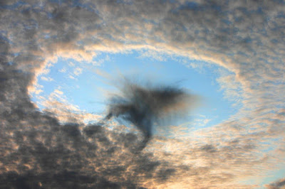
Well, it turns out that some of the new ones only form under really specific conditions.  Take, for example, one of the newly-classified cloud types, named cavum, sometimes known as a "hole-punch cloud" or a "fallstreak hole."  This occurs in an altocumulus cloud bank, when something causes sudden evaporation in a region, leaving behind a hole through which you can see the blue sky.  It's sometimes triggered by an airplane or even a meteor.

A cavum formation in Austria in 2008 [Image licensed under the Creative Commons H. Raab (User:Vesta), HolePunchCloud, CC BY-SA 3.0]

Another is the volutus, or "roll cloud," often associated with windy weather near bodies of water, and thought to be caused by a soliton wave -- a single, stable standing wave front:

A volutus cloud, Punta del Este, Maldonado, Uruguay, 2009 [Image licensed under the Creative Commons Daniela Mirner Eberl, Roll-cloud, CC BY-SA 3.0]

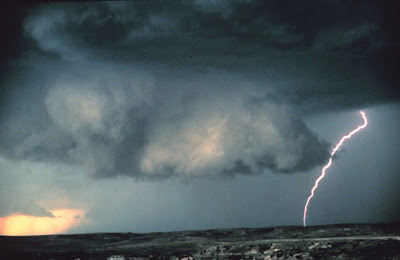
Another new one is the murus cloud, or "wall cloud."  Although this one has been seen many times, especially if you live in the midwestern United States, it just recently received its own nomenclature.  It's a part of a cumulonimbus formation -- the kind of cloud that gives rise to thunderstorms and tornadoes -- and results from an abrupt lowering of the cloud base.  This indicates the area of strongest updraft, which is why murus clouds are a good indication that it's time to head to the storm cellar.

A murus cloud near Miami, Texas, 1980 [Image is in the Public Domain courtesy of the National Oceanographic and Atmospheric Administration]

One last one is the asperitas formation, which has an undulating, underwater appearance.  While they look threatening, they're more often seen after a thunderstorm has passed, and usually dissipate quickly without any further violent weather.

Asperitas clouds over Talinn, Estonia, 2009 [Image licensed under the Creative Commons Ave Maria Mõistlik, Beautiful clouds, CC BY-SA 3.0]

Anyhow, I was really surprised to hear that those only recently got their own official classification.  I guess it just goes to show that there is still a lot to be learned from the things we look at every day.  Speaking of which, it's time for me to check the NOAA forecast site and see about those frontal systems in South Dakota.  Carol is waiting for her update.  You know how it goes.

****************************************


Wednesday, April 7, 2021

Thunderstorms on Titan

Sometimes I bump into a piece of research that's just so cool I have to tell you about it.

Yesterday when I was casting about for a topic for today's post, I found a link to a paper in the Journal of Geophysical Research called "The Physics of Falling Raindrops in Diverse Planetary Atmospheres," by Kaitlyn Loftus and Robin Wordsworth, of Harvard University's Department of Earth and Planetary Sciences.  In it, they consider the models of how raindrops alter as they fall -- evaporating, changing shape because of atmospheric drag, interacting with nearby drops -- and how that might differ not only in different environments on Earth, but on other planets.

You may already know that raindrops aren't as they're usually pictured, with a teardrop shape that's bulbous on the bottom and tapers to a point at the top; they're more or less spherical.  Large raindrops, or drops in high winds, will sometimes be deformed into fat ellipses, but modeling raindrop shapes as spheres is going to be a pretty good approximation most of the time.  Where things get interesting, though, is the fact that they sometimes coalesce with other drops, or partially evaporate as they fall.  In fact, it's the evaporation of rain on the way down, especially when falling into warm, dry air, that gives rise to my all-time favorite atmospheric phenomenon: a convective microburst.

Microbursts don't occur where I live, here in central New York, which I'm disappointed about because it'd be cool to experience one, and relieved about because having your stuff blown into the next time zone is kind of inconvenient.  They're much more common in areas that have turbulent updrafts from a layer of warm air near the surface -- like the American Midwest.  (It's no coincidence that places with microbursts are usually also prone to tornados.)

What happens is something like this.  A moisture-laden cloud reaches the point where the droplets of water are heavy enough to fall, so they do, dropping into the layer of warm, dry air underneath.  This makes the drops begin to evaporate.  Evaporation cools the air layer, and if the gradient -- the temperature difference between the blob of rain-cooled air and the hot, dry air below it -- gets big enough, the cool air literally falls out of the sky like an Acme anvil in a Roadrunner and Coyote cartoon.

If you're underneath this, all you know is that it's lightly raining, and then all of a sudden, WHAM.  The winds go from zero to a hundred kilometers per hour in thirty seconds flat.  Then equally quickly, it's all over, leaving you to pick yourself up and wander around trying to figure out where your trash cans and patio furniture went.

A microburst near Denver, Colorado in 2006. There aren't many good photographs of them because they're over so quickly, and also because if you're in one, the last thing you'll be thinking about is taking pictures. [Image licensed under the Creative Commons Unixluv, Denver-microburst, CC BY 3.0]

Anyhow, raindrops are way more interesting than a lot of people realize, as is weather in general.  If I hadn't become a science teacher I think I'd have been a tornado chaser.  As things stand, I have to content myself with frequently updating my wife about such critical information as the status of frontal systems in North Dakota, usually eliciting a comment of, "Yes, dear," which I choose to interpret as a sign of breathless fascination.

But back to the study.  What Loftus and Wordsworth did was to model raindrop behavior, and then extrapolate that model to other, less familiar environments -- like the thunderstorms on Titan, which are made of droplets of ammonia.  The authors write:
The behavior of clouds and precipitation on planets beyond Earth is poorly understood, but understanding clouds and precipitation is important for predicting planetary climates and interpreting records of past rainfall preserved on the surfaces of Earth, Mars, and Titan.  One component of the clouds and precipitation system that can be easily understood is the behavior of individual raindrops.  Here, we show how to calculate three key properties that characterize raindrops: their shape, their falling speed, and the speed at which they evaporate.  From these properties, we demonstrate that, across a wide range of planetary conditions, only raindrops in a relatively narrow size range can reach the surface from clouds.  We are able to abstract a very simple expression to explain the behavior of falling raindrops from more complicated equations, which should facilitate improved representations of rainfall in complex climate models in the future.

Which I think is amazingly cool.  The idea that we could use information about rainfall here on Earth to make some guesses about what weather is like on other planets is astonishing.  I'm sure if we ever get real data from extrasolar planets, or better data from places like Titan and Enceladus here in our own Solar System, we'll still be in for plenty of surprises; I'm reminded of the cyclic violent downpours of liquid methane on the planet where the Robinsons are stranded in the remake of Lost in Space (which, unlike the original series, is actually good).

But even having a start at understanding the weather on exoplanets, based upon speculation about the conditions and knowledge of how raindrops behave on Earth, is nothing short of fascinating.

So who knows.  Maybe soon I'll be able to update my wife about what the low-pressure systems are doing on Titan.  With luck, that will produce a better reaction than "Yes, dear." 

**************************************

This week's Skeptophilia book-of-the-week is a bit of a departure from the usual science fare: podcaster and author Rose Eveleth's amazing Flash Forward: An Illustrated Guide to the Possibly (and Not-So-Possible) Tomorrows.

Eveleth looks at what might happen if twelve things that are currently in the realm of science fiction became real -- a pill becoming available that obviates the need for sleep, for example, or the development of a robot that can make art.  She then extrapolates from those, to look at how they might change our world, to consider ramifications (good and bad) from our suddenly having access to science or technology we currently only dream about.

Eveleth's book is highly entertaining not only from its content, but because it's in graphic novel format -- a number of extremely talented artists, including Matt Lubchansky, Sophie Goldstein, Ben Passmore, and Julia Gförer, illustrate her twelve new worlds, literally drawing what we might be facing in the future.  Her conclusions, and their illustrations of them, are brilliant, funny, shocking, and most of all, memorable.

I love her visions even if I'm not sure I'd want to live in some of them.  The book certainly brings home the old adage of "Be careful what you wish for, you may get it."  But as long as they're in the realm of speculative fiction, they're great fun... especially in the hands of Eveleth and her wonderful illustrators.

[Note: if you purchase this book from the image/link below, part of the proceeds goes to support Skeptophilia!]


Tuesday, October 25, 2016

The hexagons of doom

New from the Woo-Woo Bullshit That Would Not Die department, we have: stories popping up all over the place claiming that the discovery of hexagonal clouds "solves the mystery of the Bermuda Triangle."

There are dozens of these articles all over the place, many at clickbait sites like the Daily Mail Fail, so I will only post one link -- to a dubiously-less-clickbaitish site called the Mother News Network.  In it, we find that a meteorologist named Randy Cerveny has been studying atmospheric turbulence patterns, and found that a phenomenon that creates hexagonal-shaped clouds is also likely to create the proper conditions for a microburst -- a sudden downdraft that can reach hurricane-speed in a matter of seconds (and usually dissipates just as fast).  "These types of hexagonal shapes over the ocean are in essence air bombs," Cerveny said.  "They are formed by what are called microbursts, blasts of air that come down out of the bottom of a cloud and then hit the ocean and then create waves that can sometimes be massive in size as they start to interact with each other."


Which is all well and good, and of obvious interest to weather nerds like myself.  I'm fascinated by weather, which is why I'm always updating my poor long-suffering wife about the status of low-pressure systems in Saskatchewan.  So I think the discovery is cool.

But.

You may want to back slowly away from your screen, 'cuz I'm gonna yell.

THERE IS NO SUCH THING AS "THE BERMUDA TRIANGLE PHENOMENON."

I dealt with this in a post way back in 2011.  Let me quote for you the relevant paragraph:
[T]he whole preposterous idea [of the Bermuda Triangle] was brought to the public's attention by a fellow named Charles Berlitz, who wrote a bestselling book on the subject in 1974.  Berlitz's book, upon examination, turns out to be full of sensationalized hype, reports taken out of context, omitted information, and outright lies.  Larry Kusche, whose painstaking collection of data finally proved once and for all that there were proportionally no more ships and planes going down there than anywhere else in the world, said about Berlitz, "If Berlitz were to report that a ship was red, the chances of it being some other color is almost a certainty."
So the Bermuda Triangle Mystery is actually the Bermuda Triangle Ordinary Patch Of Ocean.  But far be it from the woo-woos of the world to say, "Well, I guess we were wrong after all.  There's nothing to see here, folks."  No.  We have to keep hearing about how ancient aliens built the Pyramids, that ley lines determined the siting of Stonehenge, how you can heal yourself with crystals, and that homeopathy works.

And, heaven help us all, that there's a mysterious "Bermuda Triangle" where ships and airplanes vanish regularly, never to be seen again.

So poor Randy Cerveny has joined the rank of scientists who have had their legitimate (and interesting) research co-opted by wingnuts who then use it to support a loony claim.  I don't know how he feels about this.  Maybe he's just laughing it off.  Me, I'd be pissed.

In fact, I'm pissed enough just reading about it.  I better go check the weather forecast for Quito, Ecuador and calm down a little.  It'll also give me something to tell my wife about over dinner tonight.